Kamthi Fm
Type Locality and Naming
Pranhita-Godavari Basin. The Kamthi Formation is named after the erstwhile military station Kamthi near Nagpur by Blanford (1868). [Original Publication: Blanford, W.T., 1868. Coal near Nagpur. Rec. Geol. Surv. India 22(2), 23- 54.]
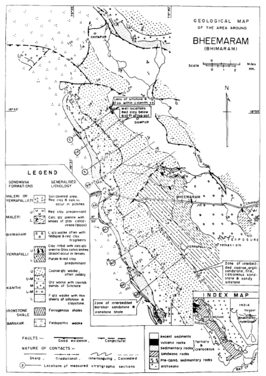
[Figure 1: Geological map of the area around Bheemaram showing the Lower and Upper Gondwana formations (Sengupta, 1970)]
Synonyms: Chintalpudi, Hingir, Mangli beds (source Sastry et al., 1977).
Lithology and Thickness
Coarse-grained sandstone to siltstone. The formation consists of conglomerates, grits, sandstones and shales. The grits are usually soft and argillaceous. They are frequently iron-stained and intersected by hard ferruginous bands of a dark brown color. The sandstones are fine to coarse grained and variable in colour with blotches and irregular streaks of red. Fine, massive and homogeneous mudstones, yellow in fresh sections but becoming red when exposed is a characteristic litho-unit. These pass into red shale (Blanford, 1868; Sengupta, 1970; Sastry et al., 1977). It is about 620 m thick (Sengupta, 1970).
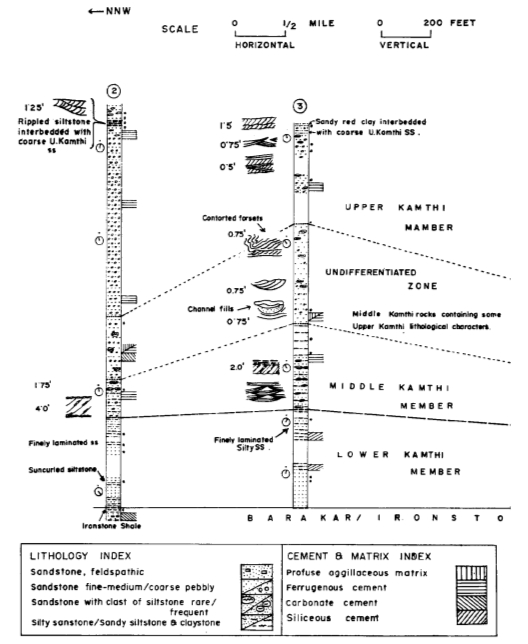
[Figure 2: Correlation of measured outcrop sections of the Kamthi Formation marked 2 an 3 on the geological map (Sengupta, 1970)]
Relationships and Distribution
Lower contact
The Kamthi Formation unconformably overlies the Kundaram Fm.
Upper contact
The Kamthi Formation has conformable and gradational contact with the overlying Yerrapalli Fm.
Regional extent
Pranhita-Godavari Basin. The formation is exposed in the south-eastern part of Godavari region as Chintalpudi Sandstone and is also present in Mahanadi valley where it is known as Hingir.
GeoJSON
Fossils
Amphibian: Brachyops laticeps (Owen, 1855); Reptile: Lystrosaurus sp. (Bandyopadhyay and Sengupta, 2006); estherids: Palaeolimnadia sp., Cyzicus sp., C. (Lioestheria) sp., (Tasch, et al., 1973; Ghosh et al., 1987); Flora: Phyllotheca indica, Vertebraria indica, Glossopteris indica, G. damudica, G. stricta, G. leptoneura, G. browniana, G. angustifolia, G. communis, Gangemopteris cyclopteroides, Pecopteris lindleyana, Pecopteris sp., Taeniopteris cf. macclellandi, T. danaeoides, T. feddeni, Noeeggerathiopsis hislopi, Equisetales, Schizoneura gondwanensis and Sphenopteris poiymorpha (King, 1881; Sastry et al., 1977; Lakshminarayana and Murty, 1990; Raja Rao, 1982; Maheshwari, 1992; Srivastava and Jha, 1997).
Age
Depositional setting
The finer grained quartz wackes of the Lower Kamthi formed channel fills in the river floodplain whereas the Lower Kamthi sandy siltstone and clays represents deposition from suspension in stagnant pools of water. The gravels and pebbles constituting the Upper Kamthi accumulated as channel lags whereas medium to coarse sands constituting Upper Kamthi were deposited mostly as point bars of the river. (Sengupta, 1970).
Additional Information
"The continued use of the ill-defined phrase “Kamthi formation” appears to be mainly responsible for the Gondwana stratigraphic correlation controversies (Dutta et al., 2015). The “Kamthi formation” included three distinctly different lithostratigraphic identities, namely, the Raniganj representing the upper part of Unit B, the Panchet representing Unit C, and the Supra-Panchet (Mahadeva Unit D). The Kamthi was, thus, assigned different ages from Late Permian
to Early Jurassic." [See "The Kamthi Problem", in S.K. Acharyya, 2019, Chapter 2 In his Tectonic Setting and Gondwana BasinArchiecture in the Indian Shield, p.11). Therefore, Kamthi Fm is used in this Lexicon only for the Permian version.
References
Bandyopadhyay and Sengupta, 2006 Blanford, W.T., 1868. Coal near Nagpur. Rec. Geol. Surv. India 22(2), 23- 54. Ghosh et al., 1987 King, 1881 Lakshminarayana and Murty, 1990 Maheshwari, 1992; Owen, 1855 Raja Rao, 1982 Sastry et al., 1977 Sengupta, S.M., 1970, Gondwana sedimentation around Bheemaram (Bhimaram), Pranhita-Godavari Valley, India. Journal of Sedimentary Petrology, v. 40, pp. 140 –170. Srivastava and Jha, 1997 Tasch, et al., 1973

